CCO Lost Vilages
The formation of the current Holderness began during the last ice age some 50,000 years ago. As the ice retreated it left behind a thick layer of glacial deposits.
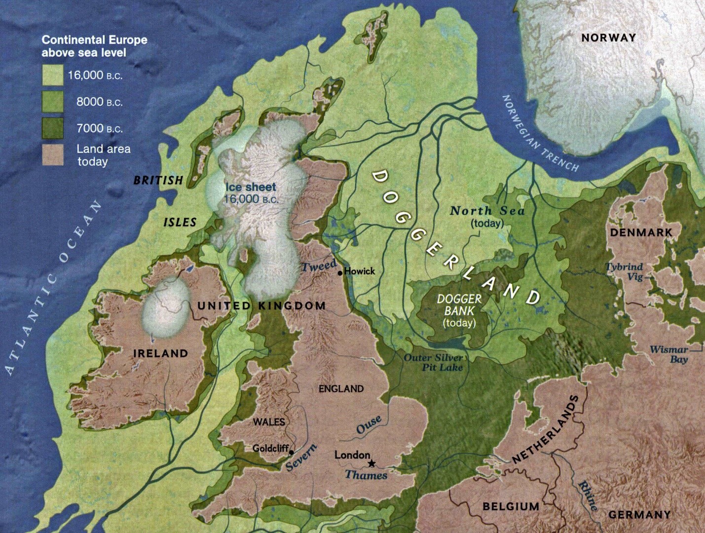
At the end of the last ice age, Britain formed the north west corner of an icy continent. Rising sea levels gradually flooded low lying lands, and some 8000 years ago the remains of Doggerland were flooded creating the Yorkshire coast we know today.
In Holderness, the glacial deposits form a more or less continuous lowland plain consisting of boulder clay. The thickness varies between 20 and 50 metres down to the more solid Cretaceous chalk.
Approximately 60 km of Holderness cliffs lie south of Flamborough, varying in height from a couple of metres up to about 40 metres at Dimlington. This stretch of coastline is composed of a variety of unconsolidated glacial deposits, dominated by boulder clay but also containing sands and gravels. This loosely consolidated stiff clay till is easily eroded by the action of waves. The relentless pounding of waves has gradually pushed the coastline back, resulting in Holderness being the fastest eroding coastline in Europe.
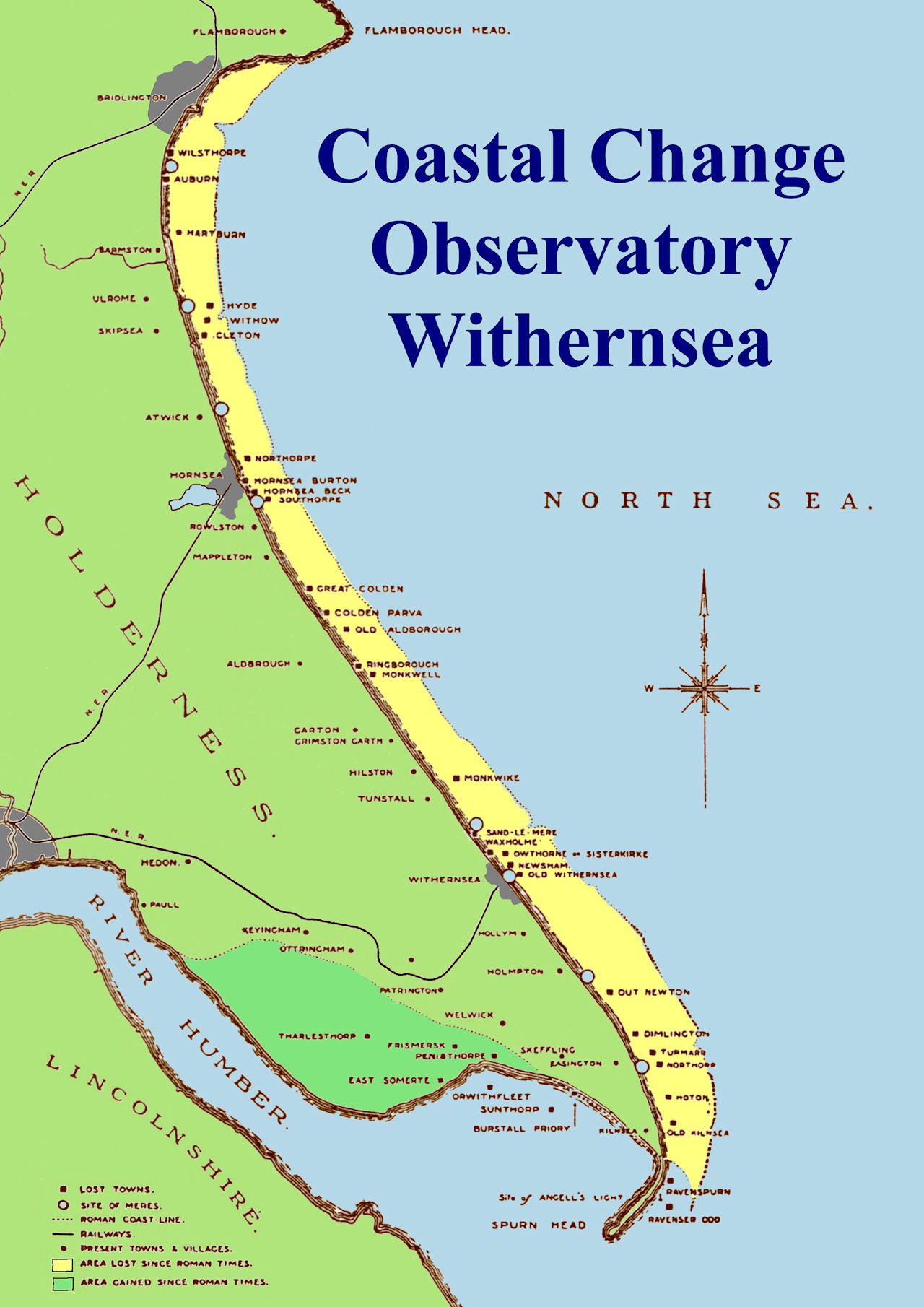
The above map is based on the Lost Towns of East Yorkshire by Thomas Sheppard. It shows the area lost to coastal erosion since Roman times (in yellow). It also shows the towns, villages and meres lost to the sea.
The North Sea is no doubt harbouring houses, churches and long-forgotten farmland, keeping the secrets of our ancestors safely hidden. All we have left of these villages and hamlets are fleeting records from medieval tax polls or written accounts from our forefathers who once lived there. There are almost 30 villages we know of that have been lost over the years. Here is what we know about some of them.
Auburn
This former village was situated around three miles south of Bridlington, and in 1870 was reported to have a population of 16 people. It had a small chapel and a couple of houses, but was lost in the late 1800s due to coastal erosion.
Cleeton
Lying just off the coast of Skipsea, Cleeton was mentioned in the Domesday Book and a manor was well documented on the site from the 13th century, but was eventually abandoned in the 16th century. It is thought the land on which the manor stood was lost in 1800, also incorporating the nearby hamlets of Withow and Hyde.
Colden Parva
In 1870, Colden Parva was described as a “chapelry” near Aldbrough, 12 miles north of Hull. At the time, it had a population of just 20 people, but as with Great Colden, was soon lost to the sea.
Great Colden
This former hamlet disappeared last century, with residents retreating inland because of coastal erosion. It was references in the Domesday Book under Coledun. The road that once led to Great Colden can still be found between Mappleton and Aldbrough, with the exposed beach area once used by the military.
Hartburn
The village of Hartburn on the Holderness coast was deserted after the 15th century and no longer exists due to coastal erosion. The village was located just south of the outflow of Earl's Dike on the coastline.
Hornsea Beck
Recordings of a settlement at Hornsea Beck reach as far back as the 1360s, with 264 taxpayers living there by 1377. Located just north of Hornsea, it is thought Hornsea Beck was more densely populated than its remaining counterpart, but from the mid-1500s coastal erosion struck. The village was completely lost by 1747.
Northorpe and Southorpe
These medieval villages were listed in the Domesday Book and surrounded the Hornsea we know today. Both villages had been completely depopulated by the early 1800s.
Owthorne
Located to the north of Withernsea, Owthorne had a church established in the late 12th century, but was washed away completely in 1816. The name Owthorne lives on in nearby street names, and the disused Owthorne Aerodrome in Withernsea, which was used by the RAF from 1917 to 1919.
Ravenser Odd
Built upon a sandbank at the mouth of the estuary, now covered by the waves of the North Sea, Ravenser Odd is believed to have been founded in the mid-1200s. Its unusual name stems from the Norse Hrafn’s Eyr, or raven’s tongue. An important port, it’s reported a market and several hundred properties once occupied the village, but after surviving for a century, the town was overwhelmed by the sea over several decades.
Ravenspurn
Ravenspurn is the name given to the eroded peninsula where the town of Ravenser Odd formerly existed. Ravenspurn weathered the storms and coastal erosion for a considerably lengthier amount of time, with its demise occurring sometime before 1700. A cross in Hedon commemorates Henry IV’s landing at Ravenspurn in 1399, on his way to dethrone Richard II. Edward IV also landed there in 1471, on his way back from exile in the Netherlands. Ravenspurn is also mentioned in three of Shakespeare’s plays – Richard II, Henry IV Part 1 and Henry VI – under the spelling Ravenspurgh.
Withernsea (Old)
Neighbouring Owthorne, Old Withernsea was largely destroyed by the 15th century. In 1444 the church had been abandoned because of coastal erosion, and within a few years the entire village had been lost to the sea. With their homes gone, villagers began moving inland, and by 1488 construction had started on the St Nicholas Church that now survives in Withernsea.