CCO Reference Materials
References
Urban Rim, East Yorkshire coastal erosion
https://urbanrim.org.uk/coastal%20erosion.htm
The East Riding Coastline - Past Present and Future, April 2017
Institute of Estuarine and Coastal Studies (IECS) The University of Hull
https://www.researchgate.net/publication/316486783
The Humber Flood Risk Management Strategy, March 2008
Environment Agency
https://assets.publishing.service.gov.uk/government/uploads/system/uploads/attachment_data/file/308278/Humber_strategy1.pdf
Internet Geography Coastal Environments
https://www.internetgeography.net/topics/coasts/
Bibliography
For people who want to research more thoroughly the history of change on the Holderness Coast and within the River Humber, the Coastal Change Observatory have produced the following recommended reading list.
Boyes, Sue; Barnard, Steve & Elliott, Michael – The East Riding Coastline: Past, Present and Future https://www.researchgate.net/publication/316486783_The_East_Riding_Coastline_Past_Present_and_Future 2017
Boyle, J R – The Lost Towns of the Humber, A Brown & Sons, Hull & London 1889
De Boer, George & Carr, A P – Early maps as historical evidence for coastal change, The Geographical Journal, Vol 135, Part 1, 3 / 1969
De Boer, George & Skelton, R A – The Earliest English Chart with Soundings, Imago Mundi 23 1969, pages 9 – 16
De Rance, C E – The Rate of Erosion of the Sea-coasts of England and Wales, and the Influence of the Artificial Abstraction of Shingle or Other Material in that Action. Fourth Report of the Committee, Report of the British Association for the Advancement of Science, 1895 pages 352 - 387
Miles, G T J & Richardson, W – The History of Withernsea, A Brown & Sons Ltd, Hull 1911
Neave, Susan & Ellis, Stephen – An Historical Atlas of East Yorkshire, University of Hull Press 1996
Ostler, Gordon – Lost Villages of the Humber Estuary, Local History Archives Unit, Hull college of Further Education 1990
Phillips, John – The Rivers, Mountains and Sea Coast of Yorkshire, John Murray, London 2nd edition 1855, pages 118 -125 & pages 279 – 285
Pickwell, R – The Encroachment of the Sea from Spurn Point to Flamborough Head, and the Works Executed to Prevent the Loss of Land, Proceedings of the Institution of Civil Engineers 51 1878, pages 191 - 212
Pye, Kenneth & Blott, Simon J – Aldbrough Gas Storage Project: Geomorphological assessment of impact of proposed cliff protection works on adjoining areas, External Investigation Report October 2010
Poulson, George – The History and Antiquities of the Seigniory of Holderness, Robert Brown, Hull 1840
Rawnsley, John E – Antique Maps of Yorkshire and Their Makers, M.T.D. Rigg Publications, 3rd edition 1983
Reid, Clement – Memoirs of the Geological Survey, England and Wales : The Geology of Holderness and the adjoining parts of Yorkshire and Lincolnshire, HMSO 1885, pages 94 – 115
Reid, Clement – Coastal Erosion, Reprint from ‘The Geographical Journal, November 1906
Royal Commission on Coast Erosion 1907 – 1911, Third and Final Report, London 1911
Sheppard, Thomas – The Lost Towns of the Yorkshire Coast, A Brown & Sons, Hull & London 1912
Spurn Heritage Coast Study – Final report, Institute of Estuarine and Coastal Studies, University of Hull, January 1992
Thompson, C – The Erosion of the Holderness coast (reprinted from the ‘Proceedings of the Yorkshire Geological Society’ Vol XX Part 1 1923 – 24, pages 32 - 39
Thompson, Thomas – Ocellum Promontorium, or short Observations on the Ancient State of Holderness with Historic Facts relative to the Sea Port & Market Town of Ravenspurn in Holderness, Thomas Tipping, Hull & London 1824
Valentin, H – Land Loss at Holderness in J A Steers (editor) Applied Coastal Geomorphology, London 1971, pages 116 - 137
Victoria History of the Counties of England, A History of the County of York East Riding; Holderness Wapentake South Volume 5 1984 edited C R Elrington, Holderness Wapentake: Middle and North Divisions Volume 7 2002 edited by G H R Kent
Maps
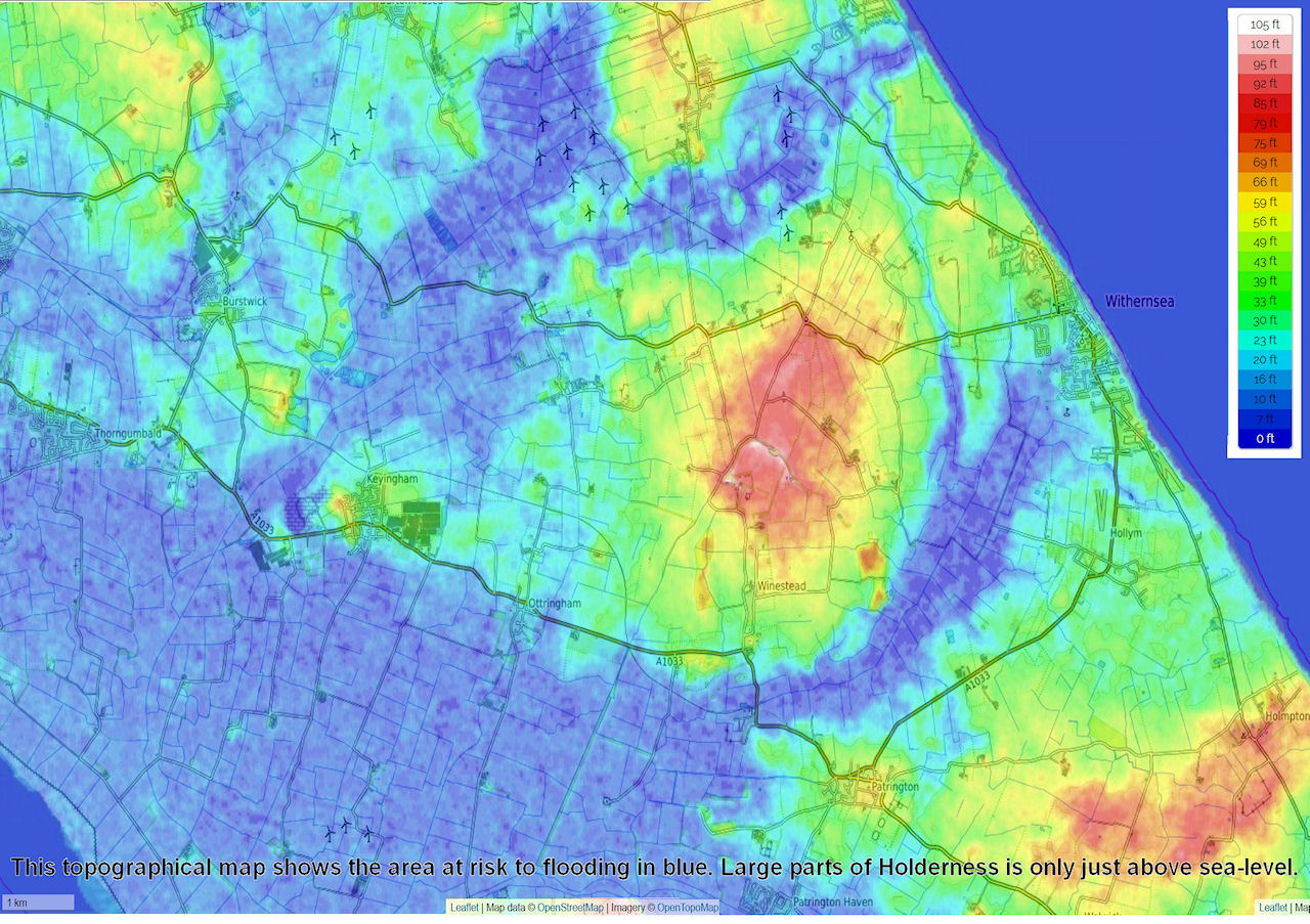
The above map is from OpenTopoMap an excelent tool to look at the topography in the area.