CCO Sand Le Mere
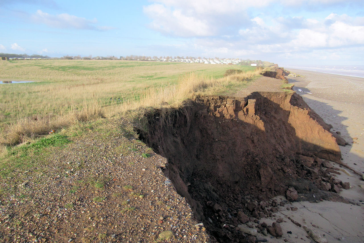
The embankment just south of Sand Le Mere holiday village is rapidly eroding away. Over half the embankment has been lost exposing the low-lying land behind it to the onslaught of the North Sea.
If the embankment is breached, the sea will flow through at high tide.
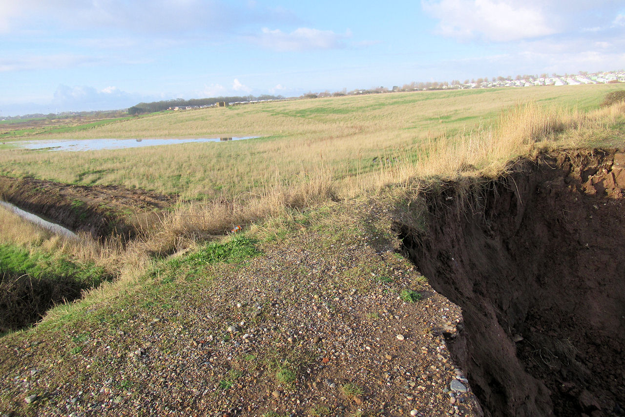
On the inside of the embankment lies the start of Tunstall drain which is below sea level at high tide.
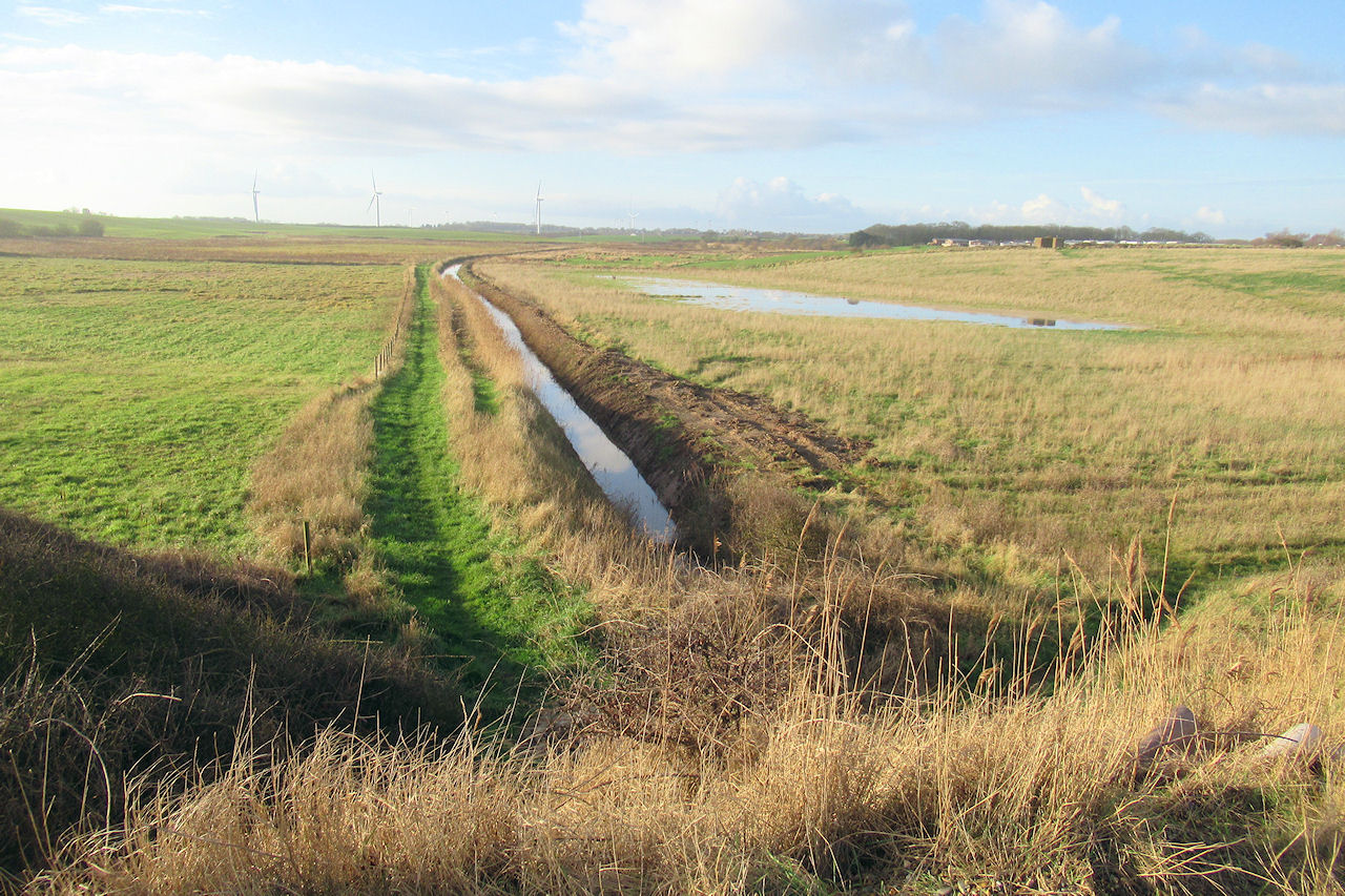
The Tunstall Drain connects with the Roos Drain, which again connects to the Halsham Drain which runs all the way through to Stone Creek on the banks of the Humber. Potentially this could cause seawater to flood quite a distance inland.

The topographic map © OpenTopoMap shows the low-lying areas in blue stretching all the way from Tunstall to the Humber.
The Yorkshire Post ran the following article about the situation on the 27th January 2016:
A public inquiry costing up to £100,000 may have to be held to make progress on plans to protect a vulnerable stretch of the Holderness coast from the sea. East Rising Council is planning £600,000 defences close to Sand-le-Mere caravan site at Tunstall where the sea is in danger of breaking through into an important watercourse.
Coastal erosion has seen chunks of cliff lost from an embankment built in the 1950s, leading to fears that in a storm water could surge into Tunstall Drain, flooding fields and villages and even cutting off a large chunk of southern Holderness. Hundreds of tonnes of rock were used to shore up the crumbling defences six years ago, but it was only meant to be a stopgap.
The plan involves building two bunds 200m inland, one over Tunstall Drain and another over a smaller drain, with sluices which can close in extreme weather so the area of land closest to the sea would flood in extreme events, rather than farmsteads agricultural land inland.
Civil engineering services manager Richard Lewis said: "The scheme will protect a significant amount of farmland from being contaminated with saltwater and it will also prevent the eastern part of Holderness from effectively becoming an island." The old embankment will be allowed to breach "naturally", eventually forming a new intertidal area, with dunes.
"Nobody knows exactly how and when that will happen, " added Mr Lewis. "The embankment is very close to the cliff top and at some point erosion will catch up with it."
Plans were passed by the council in 2014. But while the owners of Sand-le-Mere have agreed to the scheme, negotiations with the landowner to the south have failed to reach agreement. East Riding Council is now looking to use a compulsory purchase order to acquire the land, which could lead to a public inquiry, if there is an objection. A report seeking Cabinet approval for the CPO says legal advice, hiring a barrister and other technical proof could cost up to £100,000. Unopposed it could mean work starting next year - but a public inquiry would add another year’s wait.
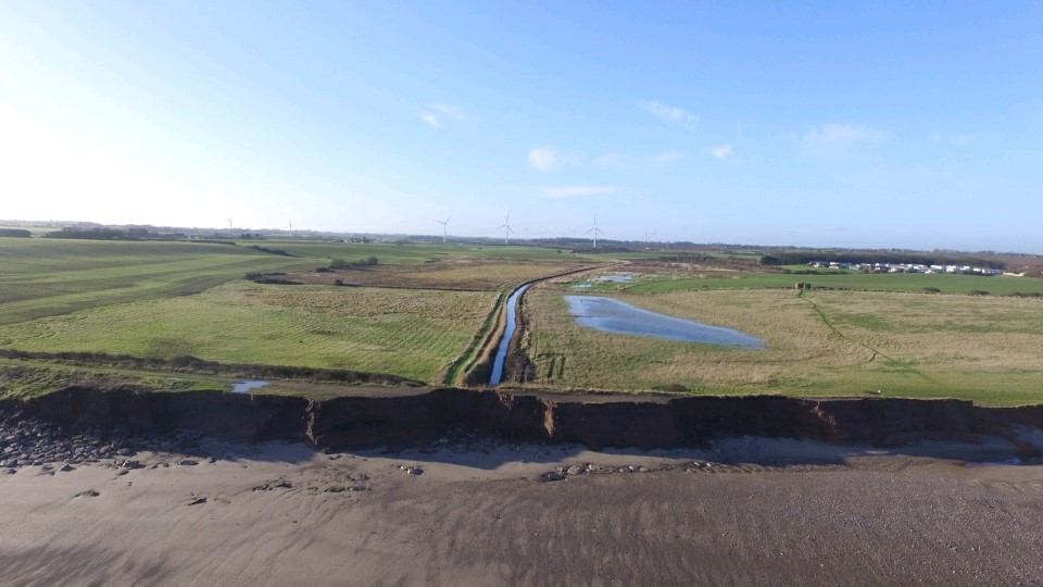
Above drone footage shows the crumbling dike protecting Tunstall Drain (Photo by Steve Medcalf)
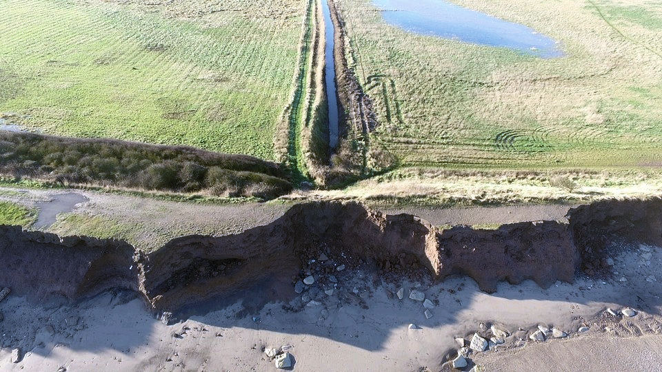
Only a couple of metres to go before the dike is breached at Tunstall Drain (Photo by Steve Medcalf)
The CCO requested an update from East Riding of Yorkshire Council and received the following response on the 16th of December 2020. They said the statement from the Environment Agency is a joint statement from both parties:
“We recognise that flooding and coastal erosion is a major concern for local people. The Environment Agency is working with East Riding of Yorkshire council and South Holderness Internal Drainage Board at Tunstall to deliver a long term strategy to manage sea flooding and adapt to coastal erosion. East Riding of Yorkshire council expect to begin work in 2021 on a new water flow control structure at Thirtle Bridge. This will allow for control of water flowing from the east meaning that flooding of land to the west of the B1242 will be much less likely. Multi-agency emergency response plans have also been developed to ensure the flood risk can be managed until the scheme has been delivered.”
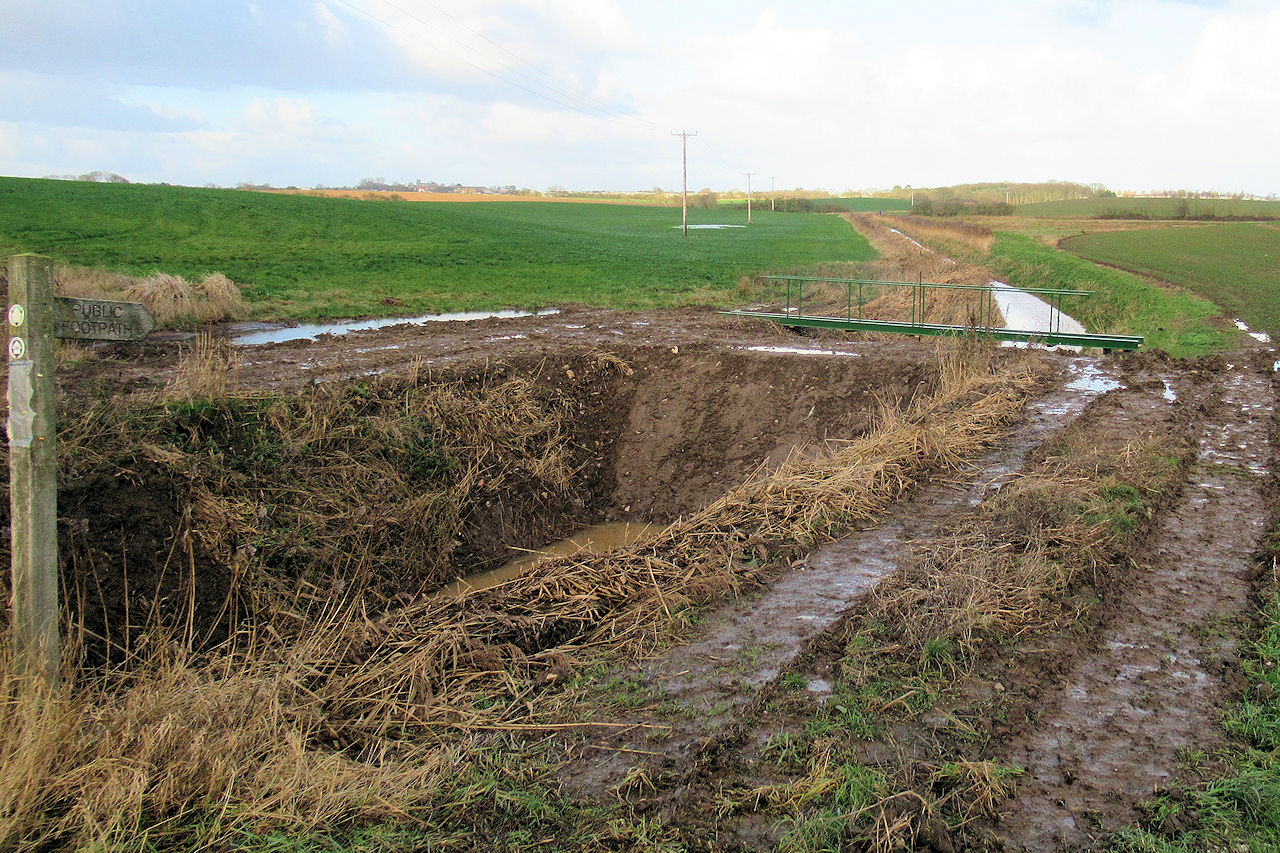
A temporary dam has recently (December 2020) been placed across the Tunstall Drain at Thirtle Bridge. There is a pipe through the dam to let some water through. Presumably this is a stop gap measure to limit the inflow of seawater when the dike is breached at Sand Le Mere.
A further ERYC press release states:
East Riding of Yorkshire Council is working with the Environment Agency and the South Holderness Internal Drainage Board on a new £600,000 scheme to replace the eroding embankment on the Holderness coastline near Tunstall with a new defence further inland, to control any sea water entering Tunstall Drain.
The Environment Agency have contributed £265,000 towards the costs of the scheme.
The scheme is due to begin immediately after Easter, on Tuesday, 6 April 2021. The council’s contractors, Breheny Civil Engineering Limited, are programmed to take 12 weeks to complete the works, with completion scheduled for 28 June, 2021.
During the works, the B1242 at Thirtle Bridge will have to be closed, and a signed diversion route will be in operation during this time.
Local residents, farmers and Sand Le Mere caravan park have been informed.
Councillor Chris Matthews, portfolio holder for strategic property and infrastructure, said: “This is a very important scheme for the people of the area around Sand Le Mere and Tunstall. We will be building a new water flow control structure at Thirtle Bridge. This will allow for the control of water flowing from the east, meaning that flooding of land to the west of the B1242 will be much less likely.
“We apologise to road users for the essential road closure during these works, but assure local residents that this scheme will bring significant benefits.”
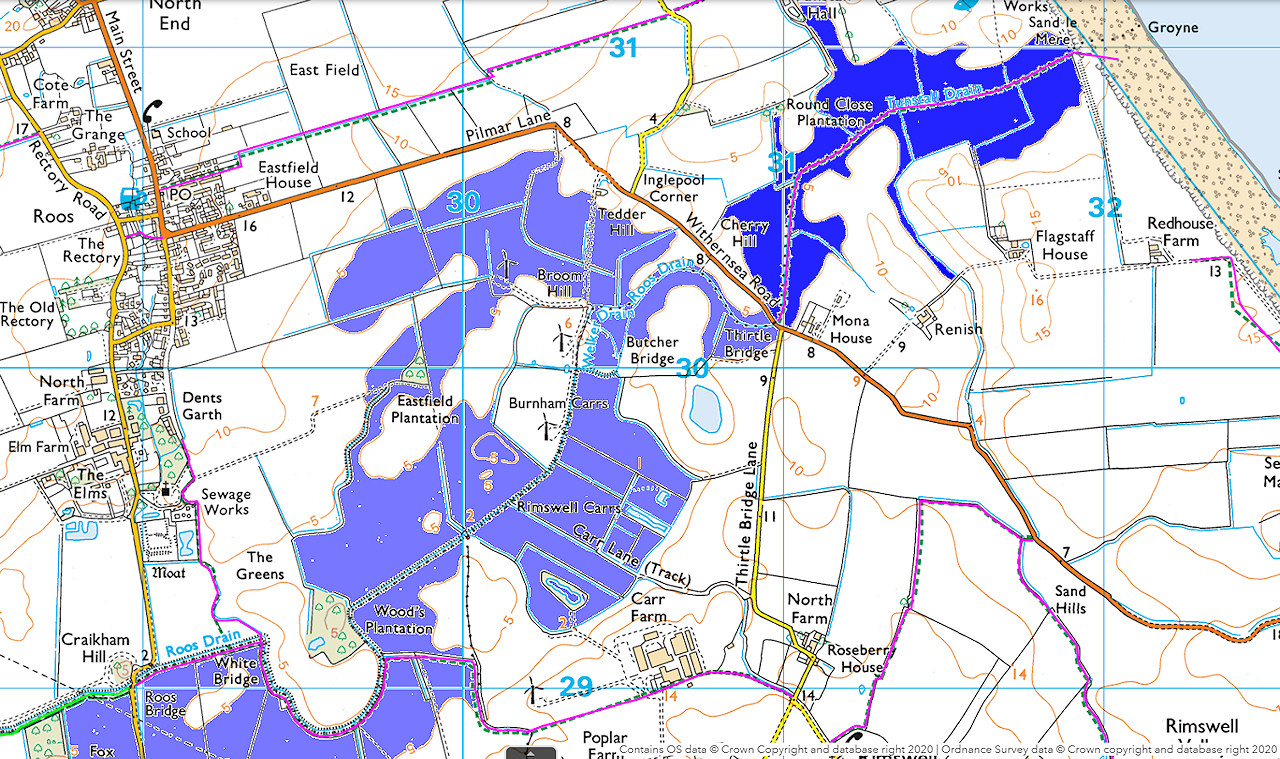
Above map shows the area in dark blue that will be flooded with seawater when the dike at Sand Le Mere is breached.
If the inflow of seawater is not stopped at Thirtle Bridge, the light blue area would also be flooded.
More pictures of coastal errosion at Sand Le Mere at Urbanrim.org.uk